
Depending on a construction site’s size, topography and visibility, traditional surveying requires manual measurements and inputs and takes a couple of days or weeks. As a solution, drone technology can make surveying much simpler and more accurate, so you can save time and take on more clients.
Compared to traditional methods for surveying, surveying with drones is a must for positioning your company for success. This article covers all you need to know about drone surveys and how they can enhance your business.
JUMP TO SECTION
What Is Drone Surveying?
Drone surveying refers to using drones or unmanned aerial vehicles (UAVs) to collect aerial data with downward-facing sensors, including light detection and ranging (LiDAR) payloads, multispectral cameras and RGB cameras.
- UAV: A UAV is an aircraft that can either be guided autonomously using software-controlled flight plants embedded in the system or remotely controlled by humans. In other words, the aircraft itself has no human pilot. UAVs operate in conjunction with a global positioning system (GPS) and onboard sensors.
- LiDAR: LiDAR is a well-known remote sensing method for measuring the exact distance between objects on the Earth’s surface. It’s used in construction, mining, agriculture and many other industries.
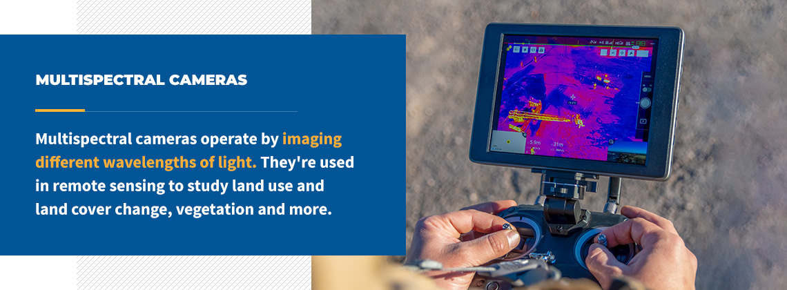
- Multispectral cameras: Multispectral cameras operate by imaging different wavelengths of light. They’re used in remote sensing to study land use and land cover change, vegetation and more. They provide surveyors with detailed analysis and enhanced target discrimination.
- RGB cameras: Unlike multispectral cameras, RGB cameras capture the same wavelengths of light as the human eye. These are typical cameras people use to take images every day.
While these are the standard drone components that aid construction, several others exist. This technology keeps developing, offering a variety of options and tools to conduct aerial surveys using drones. To help you keep up with it all, consider partnering with a professional technology solutions provider with expertise across various industries.
What Are Drones Used for in Surveying?
Drones have several uses in surveying, including:
- Cartography
- Land development and management
- Slope monitoring
- Urban planning
- Road construction surveying
- Dam surveying
- Forestry management and monitoring
- Power grid inspection
- Geological hazard monitoring
- Stockpile volumetric measurements
Advantages of Using Drones in Surveying
Land surveying with drones has several advantages. Primarily, it streamlines construction projects, but let’s dive a little deeper to help you fully understand how using drones in surveying can transform your business.
1. Comprehensive and Accurate Data
Survey drones produce precise aerial data, which is highly valued in the construction industry. The approach makes complete and accurate maps over large plots of land in a single drone flight using GPS points. Surveyors can acquire measurements of distances, elevations, surfaces and volumes free from human errors.
You can use the information to create drawings, 3D point clouds, 2D figures and more. For better insight, photogrammetry software can help you generate digital surface models (DSMs) and digital terrain models (DTMs). Additionally, the information is available in various formats, which may be necessary for comparison and auditing purposes.
Surveying with drones also makes it possible to capture valuable, minute details you might otherwise miss. There’s no need to return to the site to collect the data — the drone has that sorted. Such information could be vital in development, as it can impact land elevation or construction.
2. Saves Cost and Time
Companies that understand the value of client services and customer satisfaction know time is of the essence. Conducting topographic surveys with traditional approaches could take several days and weeks to complete, especially in situations when you’re dealing with large plots of land. Ultimately, manual survey methods are labor and time intensive.
Utilizing drones for surveying closes this productivity gap while ensuring precision and accuracy. Modern UAVs can do the job of several workers within a short time. Even if you miss essential information, you can send the drone out to get it.
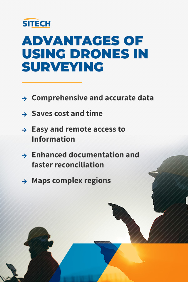
3. Easy and Remote Access to Information
Surveyors often rely on their employees and subcontractors to conduct operations on site and collect information about construction progress. Drone surveying can streamline those processes.
Using drones for mapping allows you to capture images that are accessible directly from your computer. This approach is faster and more reliable and makes it possible to have productive discussions and evaluations with site managers. You can instantly access the feed from the drone several miles away, which is challenging in the traditional world.
Remember, you can use the information from the survey data to create 2D and 3D site models. This helps you with project progress tracking. It makes overlay survey plans and progressive construction decision-making efficient and convenient. Additionally, you can assess the performance of your workers and monitor safety compliance remotely.
4. Enhanced Documentation and Faster Reconciliation
When you survey a construction site, it’s almost certain you’ll need to review numerous documents. Searching for information can be challenging, especially when it’s urgent. Further, tracing operational errors is impossible in some circumstances when you employ traditional surveying methods.
Drone data offers organized, accurate, precise and retrievable documentation at regular intervals in the construction process. With comprehensive information, you can review entire operations and identify error stages. Moreover, the data is helpful for training to improve team performance and structural accuracy.
5. Maps Complex Regions
Surveyors and contractors face several physical hurdles — complex terrains, steep slopes and unreachable areas. Previously, these obstacles could make surveying impossible or inaccurate when completed.
Land surveying with drones is a solution for venturing into otherwise inaccessible areas and a means of obtaining accurate data. It’s no longer necessary to send workers with a backup team — drones will fly over all those hurdles.
Other Benefits of Using Drones in Construction
Besides the benefits associated directly with surveying, there are other general benefits of using drones in construction worth noting. These include the following:
1. Security Surveillance
Leaving equipment unprotected on construction sites can increase the likelihood of theft. Besides affecting your budget, equipment loss could stifle your progress. Top construction companies use drones to embark on swift flyovers to check whether they’ve positioned equipment safely. With an area view of the entire construction site, you can make sure everything is in order, even when you’re not there yourself.
2. Improved Safety
Contractors comply with precautionary measures to ensure operational safety. The aerial data captured through drone technology allows you to monitor and assess hard-to-reach areas without physically venturing into these spaces. Before taking a step, you can use the data to develop a plan to maneuver any barrier.
For instance, the data gives you an idea of the best approach to survey the area and the expertise required to execute the task. Additionally, the information is vital in inspection and maintenance works. Instead of climbing ladders or scaffolds to reach great heights, an automated drone inspection is a safe alternative.
Another essential aspect of safety is monitoring compliance. Sometimes, providing workers with safety apparel and tools isn’t enough — it’s also necessary to reasonably ensure your employees comply with those protocols. Drones can cover large areas on the construction site and take shots of ongoing activity, allowing you to get a full picture of a site’s safety.
What Kind of Survey Results Can Drones Accomplish?
You can use the aerial data to create geo-referenced orthomosaics, 3D models, thermal maps, multispectral maps and LiDAR point clouds. Other deliverables include DTM, DSM, contour lines and 3D texture mesh.
1. 3D Models
A primary deliverable of drone surveys in modern construction operations is 3D models. Fundamentally, drones function as airborne scanners, which capture datasets concerning large objects, including buildings and construction sites. After that, you can create a 3D model with geospatial and color information.
2. 2D Orthomosaic Maps
Most drones have 2D photogrammetry mapping features, including orthomosaics. As the drone hovers above the surface, it captures hundreds of pictures. Those several pieces of images are put together to form a 2D orthomosaic map. Each pixel contains an X/Y axis and color information. With the help of 2D orthomosaic maps, you can accurately measure the distance between specific distances.
3. 3D Orthomosaic Maps
The main challenge of using 2D orthomosaic maps is the distorted regions on the map. With 3D orthomosaics, you can create three-dimensional models from the images captured by drones. This gives better topographic data compared to the 2D versions. You can create 3D orthomosaic maps using building information modeling (BIM) software.
4. LiDAR Point Clouds
LiDAR is an aerial mapping technique using a laser to measure the height of the terrain and the surface objects such as buildings and trees. A LiDAR point cloud is a collection of thousands to billions of highly accurate three-dimensional X, Y and Z points and component attributes. These produce a high-density point cloud for the site survey.
5. Multispectral Maps
Another essential deliverable of drone surveys is multispectral maps. These are images captured within a specific wavelength range on the electromagnetic spectrum. The technology has broad applications, including military, agriculture, health care and construction. In construction, you can use multispectral maps to characterize land features.
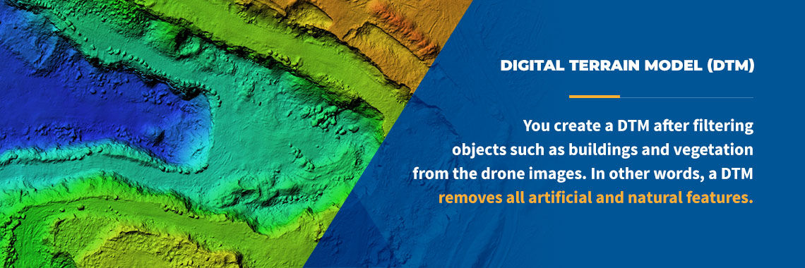
6. Digital Terrain Model (DTM)
A DTM is a topographic model of the bare-Earth surface that contains the terrain’s elevation data in digital format. You create a DTM after filtering objects such as buildings and vegetation from the drone images. In other words, a DTM removes all artificial and natural features.
7. Digital Surface Models (DSM)
A DSM represents the elevation of natural and human-built features on the surface of the construction site. It captures the topmost surface of the area — the reflective surfaces of elements elevated above the bare Earth.
8. Contour Lines
Depending on the DTM or DSM models with custom internals and project requirements, you can create a contour lines map that provides in-depth information regarding the surface area shot by the drone.
9. 3D Texture Mesh
This is a reproduction of the faces, edges, texture and vertices of the construction site shot by the drone. 3D texture mesh models are helpful during visual inspections, especially when public or external stakeholders are involved in the project.
10. Thermal Maps
Thermal drones survey with a thermal camera identifying the targets with abnormal heat signatures. You can use this to survey complexes, cities, facilities, campuses and more. Thermal maps enable you to monitor supply water mains, hot water lines, condensation return lines and steam pipes during construction. These maps help you prevent breakages or identify leaks.
How to Integrate Drones into Your Business’s Workflow
As technology advances and more companies implement drone programs, developing strategies to integrate them into your workflow becomes essential to improve your return on investment (ROI). Here’s more information to assist you in building an effective drone-integration strategy:
1. Know the Challenges of Implementing Drone Programs
The first step is to learn about the common challenges businesses face when implementing drone programs and assess whether you’re likely to encounter any. This would give you a clear idea of what to expect. The common challenges businesses encounter include the following:
- Bureaucracy and delays
- Insufficient understanding of the significance and uses of drones and other technologies
- Lack of compliance with industry standards
- Scaling challenges
- Lack of coordination between teams and departments in the organization
2. Assess How Drone Technology Will Help Your Business Grow
Learn the benefits of drones and how they can make your business more efficient. Examining how UAVs cut cost, labor and risk while improving accuracy, workflow, efficiency and communication on construction projects is a motivation to implement an effective strategy.
3. Consider Specific Areas to Integrate Drone Applications
Almost every industry benefits from drone technology. However, it’s vital to assess your individual business’s needs and identify the specific areas where you need to employ drone services. With this information, you know exactly where, when and how to use your drones. When assessing the areas to implement the strategy, consider the following:
- Assess whether your business requires an in-house, outsourced or hybrid drone program, bearing in mind the specific services available and the level of expertise needed.
- Examine the information relevant to creating a standard operating procedure policy, checklist or manual to guide the team in planning, deploying, operating and managing the service.
- Set up a data governance policy for implementing the drone application within your external and internal systems.
- Ensure the services align with the business’s immediate and future demands.
- Identify the specific technology, sensor and platform requirements for the business’s construction projects.
- Implement the drone-integration strategy.
4. Implementing the Drone-Integration Strategy
The implementation stage requires efficient collaboration between relevant parties in your company. In some instances, it’s necessary to include third parties. Here’s a brief overview of the steps you might take:
- Communicate clearly and regularly with all stakeholders.
- Encourage the appropriate stakeholders to buy in.
- Set up a team to handle daily drone-related activities.
- Involve all groups in significant tasks and decisions.
- Improve workflow efficiency of the existing internal business structure.
- Consult a trusted technology solution provider.
Contact SITECH Southwest to Help Get You Started With Drone Surveying

Quality, detail-oriented, personalized solutions are crucial to implementing a successful drone surveying strategy. SITECH Southwest is the leading technology solutions provider for several industries, including construction, mining and agriculture, in Arizona and southeast California.
We offer only the best hardware and software in the industry to revolutionize how you operate. Our goal is a positive relationship with every client — we’re always willing to work with you whenever you need our expertise. Contact us today and take advantage of our advanced solutions to grow your business!