
Trimble Navigation, founded in 1978 by Charles Trimble, was developed to provide technology to the survey and GIS industries. Sometime in the late 90’s, Trimble started bolting survey hardware onto heavy machines, like bulldozers and excavators, forcing operators to understand surveying principles.
JUMP TO SECTION
Introduction to Trimble and SPS
Trimble Earthworks is one of the survey-based systems that includes computer displays inside the cab so an operator can see the cut and fill to navigate the design. To complement this technology, Trimble built a line of ground survey systems called Site Positioning Systems (SPS) to augment surveying capabilities by machine control operators.
Ideally, if an operator is taken off a machine and needed to use a survey pole, he could efficiently run the survey pole because it looks the same as the system in the dozer. This was intended as a simplified version of the full-blown geospatial survey systems that operate like the machine control systems. These systems have now evolved so that the SPS line of equipment is a fully capable survey construction system and overlaps with the geospatial survey controller on many levels.
I’m not sure if this was the plan for Trimble but these systems have been very successful at saturating every corner of the surveying industry. We have construction surveyors using the geospatial version of survey controller to layout highways, and we have licensed land surveyors using SPS SiteWorks to put in property corners.
Understanding Site Positioning Systems
Trimble created survey products to improve accuracy for heavy machinery operators. The Heavy Civil division encompasses the SPS line of applications that include SPS Trimble Earthworks as a construction site application and Cat MineStar Terrain. A couple of big takeaways here – as a precision machine control grading solution, Cat MineStar Terrain operates for mining as Trimble Earthworks does for construction. For on-the-ground survey, Trimble SiteWorks works for either, making SiteWorks a very useful tool. In the Southwest where there’s a high concentration of active mines, Trimble SiteWorks is used by most mining survey departments.
Data Challenges and Solutions
For a better understanding of how SPS applications can greatly improve workflow, here’s what a typical day of mining engineering looks like. Mining topography is updated daily due to the thousands of cubic yards of muck being moved by big shovel and mining trucks. Mine Engineers are constantly using maps for short range planning. Surveyors are required to survey in mining crests above shovels, locate new ramps, drop cuts, blast lines, power poles and shoot stockpile crest. This process is called “Progress.”
The goal of the survey department is to keep one map updated all the time with a defined set of layers and objects. The result is that engineers, ore control, drilling and blasting all have an updated map that is understandable and available at any given time. As easy as the process sounds, many mines struggle with this. Mine Planning Engineers keep their own maps with their own layer control that causes surveyors to update multiple maps. Everybody has separate projects, there is no common layer control or naming convention, and this creates an environment where surveyors are duplicating work. By the way this is not just a mining problem; these same challenges exist in many other industries like construction and municipalities.
Leveraging SiteWorks for Organization
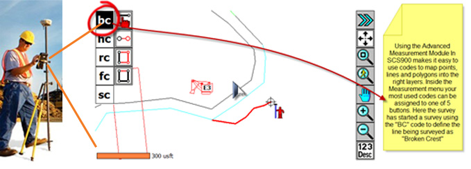
As described, Trimble SiteWorks is a useful multifaceted application. One major example is you can add the Advanced Measurement Module (AMM) to give you more control in the field. AMM allows for the use of feature codes to capture additional information about the objects being located (e.g. photos, dimensions, conditions, and material type) that control valuable information about features, layers, and objects. Setting up an AMM in Trimble SiteWorks standardizes data from the field to the office.
Implementation Process
SiteWorks field software with AMM allows the user to create their own Feature Code Library. If your engineering department is not using common layers and has no common site map, then this is a great place to start. On the other hand, if your site is using a common map and already has a definitive naming convention, then hopefully this process can help you maintain and simplify your process.
Typical data flow process . . . easy as one, two & three!
- Open a new project in Trimble Business Center
- Site loaded with a feature code library
- Mine map loaded into site
- Designs created for SiteWorks
- Work order created for progress job
- Surveyor picks up his SiteWorks data logger and heads to the field
- Conduct in the field mapping progress using feature codes from the library.
- Back in the office, when all the progress is done, the surveyor plugs his SiteWorks into the computer, syncs his data, opens Trimble Business Center, and updates his survey data. All the new data is uploaded into the proper layers with the correct colors and symbols as defined in the master map.
Ready to get your crew trained on Trimble Siteworks? We offer beginning grade checking and site management Siteworks classes. Just check our training schedule for upcoming class dates. We also offer one-on-one and individual group sessions. Contact us for more information!