
Simplifying your map maintenance process can relieve a lot of double work improving time, and frustration, and more importantly communication from the field to the office.
JUMP TO SECTION
 What is Trimble Siteworks
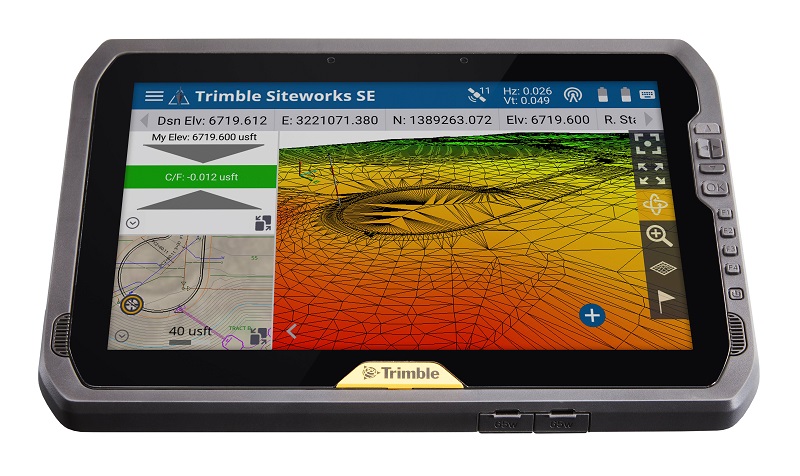
Trimble SiteWorks is software that runs on the Trimble field controller. Surveyors use it to survey using GPS or Total Stations to handle complex files and 3D data sets.
Using the Advanced Measurement Module
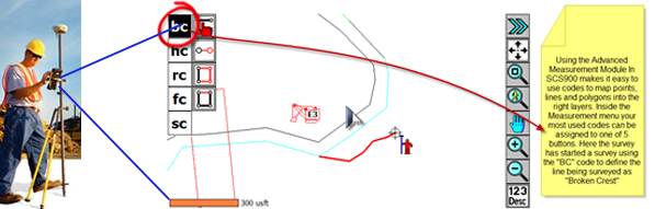
With Trimble SiteWorks you can add the Advanced Measurement Module (AMM) for more control in the field. AMM allows for the use of feature codes to capture additional information about the objects being located. For example: photos, dimensions, conditions, and material types control valuable information about features such as layers, colors and objects. Setting up an AMM for your mine standardizes data from the field into the office.
A Typical Mining Problem ~ keeping maps updated
Mining topography needs to be updated daily. Big shovel and mining trucks are moving thousands of cubic yards of muck. Mine Engineers rely on maps to ensure efficiencies for short range planning. Surveyors are required to survey in mining crests above shovels, locate new ramps, drop cuts, blast lines, power poles and shoot stockpile crest. This process is called “Progress.”
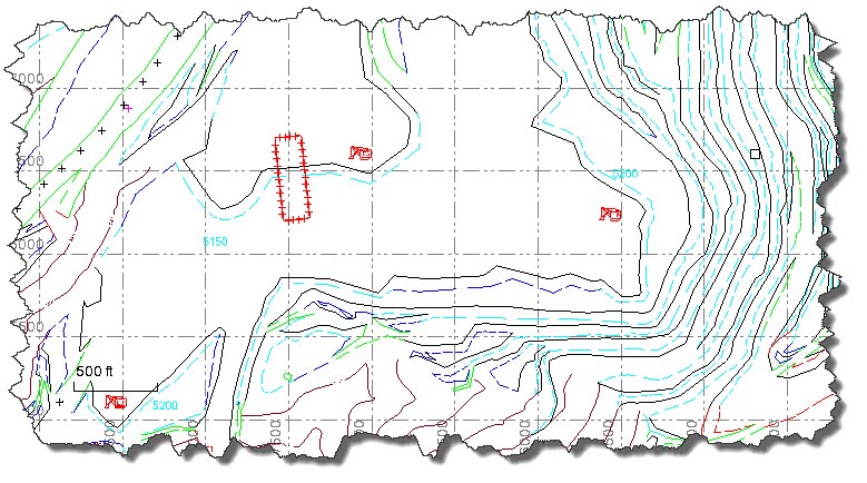 The goal for the survey department is to keep one map updated all the time with a defined set of layers and objects. The result is that engineers, ore control, drilling and blasting all have an updated map that is understandable and available at any given time.
Many mines struggle with this. Mine Planning Engineers keep their own maps with their layer control, so the surveyors are then tasked with updating multiple maps. Everybody has separate projects which results in no common layer control or naming conventions. This creates an environment where the surveyors are duplicating work, and this is not just a mining problem. You see these same types of challenges in many other places like construction projects and municipalities.
Solution ~ SiteWorks Advanced Measurement Module
SiteWorks field software with AMM allows the user to create their own mining Feature Code Library. If your engineering department is not using common layers and has no common mine map, then this is a great place to start. On the other hand, if your mine is using a common map, and have definitive naming conventions, then hopefully this process can help you maintain and simplify your map maintenance process. Let’s look at how all this works.
The typical data flow of a system in place . . . easy as one, two & three!
- Open a new project in Trimble Business Center
- Site load with a feature code library
- Mine Map loaded into site
- Designs created for SiteWorks
- Work order created for progress job
- Surveyor picks up SiteWorks data logger and heads to the field
- In the field, map progress using feature codes from the library

- In the field, map progress using feature codes from the library
- Back in the office, when all the progress is done, the surveyor plugs his SiteWorks into the computer
-
- Syncs the data
- Opens Trimble Business Center and updates the new data from the field
- New data comes in on the proper layers with the proper colors and using any symbols defined in the master map
For more information on how to improve your jobsite communication with Trimble SiteWorks CONATCT US.