
JUMP TO SECTION
Developing a Solution
 There are few places better suited for Unmanned Aerial Systems (UAS) than mining sites. In the United States, despite all the complex rules and regulations, it is the deliverables that are driving the use of UAS. Deliverables such as near real-time topography and imagery.
My work covers a large territory of mining communities. The focus is on off machine engineering systems that include GPS, Total Stations, Scanners, LiDAR and UAS.
A significant amount of time has been dedicated to developing what has become a productive UAS program for mining. It has been an extremely fast-moving target. Going from a series of photographs to accurate and consistent data has not been easy. Starting in 2016, we had a warehouse full of overly complex and outdated UASs. Through the trials and tribulations, I can say that we are UAS experts.
A Simple Solution
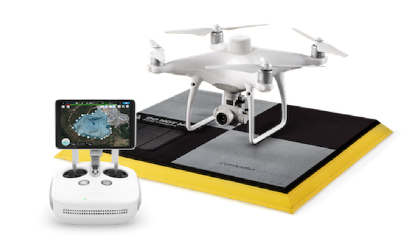
It’s great to have a straightforward simple solution that delivers consistently accurate data. We are excited to work with DJI and Trimble Stratus to form a fully integrated system for collecting highly accurate surveying and mapping data. The integrated system consists of a DJI high-precision Phantom 4 RTK Drone, an active GNSS enable ground target called an AeroPoint™ and Trimble Stratus for processing. We have been rolling this out to the mines over the last year and the implementations have been met with great success.

 How does this work?
The system comes in a complete mining kit with everything needed.
Step 1 Take the AeroPoint out and place it on a control point. Turn it on. It is now collecting static GPS data. A best practice tip is to survey a couple of extra targets depending on the area being flown.
Step 2 Using DJI GS RTK remote controller you can perform your mission planning by drawing a polygon around the area to be surveyed. Initiate the flight and the drone will take off and fly the area all on its own including coming back and landing.
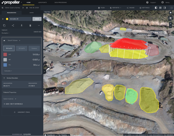 Step 3 Download the photos, flight logs and PPK data from the AeroPoint up to Trimble Stratus to be processed. Depending on the size of the flight, it can take up to one day to process. Once processing is complete, you can access your data via the Trimble Stratus website to download point clouds, contours, and aerial images.
This is an easy system that delivers consistent data and any a technician or surveyor can operate it. We have been very successful with our clients in delivering, training and supporting this solution. For more information please check out the Trimble Stratus web page https://heavyindustry.trimble.com/en/products/trimble-stratus.